Tuesday, May 09, 2006

“The Old City Cemetery” A Painful Legacy


When you first drive in to the Lynchburg, Virginia’s, Old City Cemetery you get the feeling that you have entered just another old graveyard. However, once you park and begin to explore you soon find out that this “old cemetery” is not just any old cemetery. Instead, it is engulfed in history, the history of a sad and painful time in American history; the Civil War era.

The Station House Museum tells the story of the railroad during the era and its importance to the areas economy, life and death of Lynchburg residents and the rails importance to the soldiers of WW 1 (1917-1919) that passed through Lynchburg on their way to the coast and the war. These soldiers dubbed Lynchburg, “Lunchburg”, because of the hospitality of the Red Cross Canteen service which provided these soldiers with food and drink on their stop in Lynchburg.

The three major railroads that ran through Lynchburg in1864, turned the city in to a regional hub of industry and tobacco and made it one of the wealthiest cities per capita in the United States. During the Civil War, the railroads made Lynchburg the second largest hospital center in Virginia.

The Hearse House tells another part of a devastating and sad time. Across the cobble stone road, resting on a hill is the Pest House Medical Museum, one look inside reveals the crudity of medicine during the time. One can only imagine the screams of pain of a recent amputee and impending infection which followed. You can sense the overwhelming adversity endured by not only the Pest House patients but of Dr. Terrell, Rev. Louis and the missionaries that ministered to the “spiritual and medical needs of patients. During the Smallpox epidemic of 1862-1864, it is said that no one but these brave and hardy souls were the only ones that would go near the place.

Entering the Confederate Cemetery and seeing the rows of markers, over 2200, a good number of which are unmarked, you can’t help but feel how painful it was for the families of these lost soldiers: not only eventually knowing that their loved one had likely died, but where they had died, and where there remains rested as well as never having any real closure.

In the Confederate Cemetery, soldiers from fourteen states rest there, from Virginia to Florida, west to Texas. One-hundred eighty-seven Union soldiers (prisoners) died in Lynchburg Hospitals and were buried in the cemetery until 1866 when they were removed by the Federal Government and ordered to a Federal Cemetery near Norfolk Virginia.

The gardens, selected trees and the old brick walls, among other things lend a rejuvenation of life that helps, if only briefly, relieve some of the pain of America’s reflective history.


First published on the Blue Ridge Gazette.


Technorati Tags:

Sunday, May 07, 2006

The Seminole Trail—Connections Made


Image: by D L Ennis, Mother and Daughter dance at a Monacan Powwow in Amherst County, Virginia.

How did the “Seminole Trail" along US Route 29 in Virginia, get its name? Good question and it will likely remain a mystery forever. We know that in 1928, Virginia's General Assembly voted to name route 29 the Seminole Trail. “Ann L. Miller, a Virginia Department of Transportation historian, said the act -- Senate Bill 64 -- gives no clue why they picked that name or who initiated the proposal.”

The Answer Man, as he’s called, of the Washington Post says,


Many early roads followed old Indian trails, so you might expect that to be the case here. There's just one hitch: The Seminoles aren't a Virginia tribe. They never have been. They're mostly connected to Florida, where they were born from the fragments of earlier tribes that had sparred with colonists as well as runaway slaves who were looking for freedom.


He’s right that, “Many early roads followed old Indian trails…” He is also right that, “The Seminoles aren't a Virginia tribe.” However, is has been argued by, Joseph Opala, an anthropologist at James Madison University in Virginia, (who has studied the Seminole since the 1970s) that the Seminoles were a multiethnic tribe from their beginning. This is to say that the Seminoles are a permutation of various tribes as well as runaway slaves.

The Seminole were originally part of the Creek, and they began to migrate from Southern Georgia to Northern Florida in the later half of the eighteenth century. Other tribes that mixed with the Seminole were the Timuquan, Calusan, and Muskhogean. Other tribes in the area were the Choctaw, Chickasaw, Cherokee, Yuchi, Yamassee and Apalachicola and it is likely that members of these tribes also came to be with the Seminole.

Now back to the fact that the Seminole were never a Virginia tribe and speculation as to why route 29 in Virginia would be named the Seminole Trail.

Though the Seminole were never a Virginia tribe there are some things that connect them to Virginia. The first, and probably most obvious, would be the Cherokee. The Cherokee originally inhabited most of the southeast of the United States, including Virginia, Georgia, and Florida.

The next connecting factor would be the runaway slaves who runaway and took shelter with people who accepted them, the Seminole. It is known to be fact that slaves from as far north as Virginia fled and joined the Seminole some even intermarried with the Seminole. There is some speculation that the Seminole actually enslaved the runaway black slaves themselves at first, but I could not find enough proof in my research to see this as fact.

The most important connection between Virginia Indian tribes and the Seminole, I found very interesting and to me shows an element of proof that there was a definite substantial connection at some point in their history. This all important connection is language.

The Monacan tribe of Amherst County, Virginia spoke a form of Siouan. The Seminole spoke Hokan-Siouan. The fact that a Virginia tribe, the Monacan, and tribes from Georgia who we know became part of the Seminole, such as the Muskogean, both spoke a form of the Siouan language is an unarguable connection.

The Answer Man, of the Washington Post says,


So why name a Virginia road after them? Though historians aren't certain, it appears it was an act of 1920s boosterism. Officials wanted to remind people that Route 29 wasn't just for getting from Culpeper to Ruckersville -- it was also the road that leads all the way to the sun and fun of Florida, the Seminole state.
I don’t think that the Answer Mans theory of boosterism carries as much weight as the other connections that I have shown here. During the 1920’s roads were few and of low quality, not to mention that travel was still relatively slow, so people would not likely travel far out of their way to use one road as opposed to another. I think that boosterism in this case would have been a ridiculous reason for naming route 29 The Seminole Trail. Instead, I think that the most reasonable reason for the name would be the fact that Indians, runaway slaves and others used the same trail for ease of travel and that The Seminole Trail earned its name long before the need for modern numbered roads.

The Seminole Trail was a road to some semblance of a free life for many, through the turbulent times of America’s the 18th and 19th centuries, leading to the Seminole. Let’s give credit to those who forged the trail in question for the suffering they endured in doing so.

First posted on Blue Ridge Gazette.

Technorati Tags:

Saturday, May 06, 2006

Henry Box Brown


Image: James McKim (right) receives Henry Box Brown in Pennsylvania

Henry Box Brown was born a slave Louisa County, Virginia, in 1815. He married a local slave but in 1849 his wife and children were sold to a plantation owner in North Carolina. Soon afterwards Brown decided to escape and with the help of a sympathetic tobacconist, he arranged to be sent in a box to James McKim, an anti-slavery campaigner in Pennsylvania and a member of the Underground Railroad. Brown survived the journey and as well as becoming a well-known speaker for the Anti-Slavery Society, he wrote his autobiography, Narrative of the Life of Henry Box Brown (1851).


WSET 13 has an interview with an actor who is doing a one man show about Henry Box Brown:


Lynchburg, VA - In the mid-1800s, he put himself in a wooden box and shipped himself from slavery to freedom. Henry Brown came to be known as 'Box.' Now, the story of Box Brown is coming back to life. In our Good News Friday report, we meet the actor with the one-man-show about that daring trip.

Mike Wiley, Actor - "Upon being transported to another mode of travel, again, I heard some workers say there was no more room -- for my package. So, you know what I did?"

From Performance Video - "I prayed. Oh Lawd. I prayed ‘til my knees went white and ashy."

Wiley - "I prayed and I prayed and I was placed aboard, upside down."

For us, and on stage, Roanoke's Mike Wiley portrays what it must have been like for the real Henry 'Box' Brown to send himself in a box from southern slavery to freedom in Philadelphia.

Wiley - "It's an experience for everyone."

That Wiley says applies today.
You can see "One Noble Journey" Friday night. It starts at 7:30 at Liberty University's Fine Arts Building. Tickets are $10.

You can read the rest of the interview here.


First posted on Blue Ridge Gazette.


Technorati Tags:

Friday, May 05, 2006

A Brief History of the Kanawha Canal Project


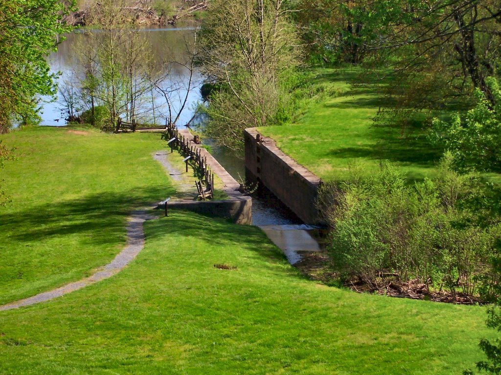
Image: by D L Ennis, Battery Creek Lock on the Kanawha Canal near the James River Visitor Center on the Blue Ridge Parkway

The James River and Kanawha Canal project was first proposed by George Washington when he was a young man surveying the mountains of western Virginia. He was searching for a way to open a water route to the West, and thought his proposed canal would be the key to helping Virginia to become an economic powerhouse in what would eventually become the United States.

Washington had identified the Potomac and James rivers as the most promising locations for canals to be built to connect with the western rivers by 1772. His preference was the James, as the Potomac led to rivers in land disputed with Pennsylvania and would be equally helpful to Maryland, whereas a canal along the James could be aligned with the Kanawha River (in what is now West Virginia), and would best serve only Virginia, which was his priority. In 1785, the James River Company was formed, and George Washington made honorary president, to build locks around the falls at Richmond. By then, Washington was rather busy with the affairs of the new nation which would elect him as its first president in 1789.

In those days, waterways were the major highways of commerce. Early development of the colonies along the east coast tended to end at the head of navigation of the rivers. Such early communities in Virginia included what we now know as Alexandria on the Potomac River, Fredericksburg on the Rappahannock River, Richmond on the James River and Petersburg on the Appomattox River.

Image: Batteaux, New York State Military Musuem

Due to the efforts of George Washington, Edmund Randolph, and John Marshall, the first commercial canal in the United States, stretching from Richmond to Westham and paralleling the James for seven miles opened in 1790. The canal expanded the existing bateaux transportation on the James River. Bateaux were flat-bottomed boats which were laden with tobacco hogsheads, drifted down the James River to Richmond and returned with French and English imports such as furniture, dishes, and clothing. The canal boats were packets, which drew more water than the smaller capacity bateaux. Mules and horses pulled the packet boats along the towpaths which ran beside the canal.

Locks were built as a necessity at points where the river had rapids, in all 90 lift locks raising water levels more than 700 feet would be incorperated into the canal system. However, the American Revolutionary War and the War of 1812 each slowed construction. Work was slow, expensive, and very labor intensive through the rocky terrain of Virginia's Piedmont region, which is a transitional area between the sandy coastal plain and the mountains. Much of the hardest work was done largely with slave labor, rented from plantation owners near the route of the canal. Work stalled for a number of years, and the James River Company went broke and gave up.


Image by D L Ennis, One of the lock gates at the Battery Creek Lock

In 1820, the Commonwealth of Virginia took control of the James River and Kanawha Canal and resumed construction only with the financial help of state funds through the Virginia Board of Public Works. Work stalled yet again, and in 1835, construction of the James River and Kanawha Canal resumed under the new James River and Kanawha Company, with Judge Benjamin Wright as Chief Engineer. He was assisted by his son, Simon Wright, and Charles Ellet Jr., and Daniel Livermore. By 1840, the canal was completed to present-day Lynchburg.
Eventually, the canal was extended 196.5 miles west of Richmond to Buchanan by 1851. From there, it was planned to linked with the James River and Kanawha Turnpike to provide passage through the most rugged portions of the mountains to reach the Kanawha at its head of navigation about 30 miles east of today's Charleston, West Virginia.

The portage necessary made competition with the railroads a real threat, but construction of a planned railroad across the portage route was delayed by the American Civil War (1861-1865). However, with the damage done to the canal system and increasing funtionality and spread of the railroad, rendered the canal obsolete shortly after the war had ended. By the time the Chesapeake and Ohio Railway was built through to the Ohio River in 1873, the doom of the canal was clear and it was sold to the Richmond and Allegheny Railroad company, which built tracks along the towpaths. That railroad was sold to the C&O, and today, the old canal route is followed by CSX trains loaded with coal from the mountains headed to port at Hampton Roads.


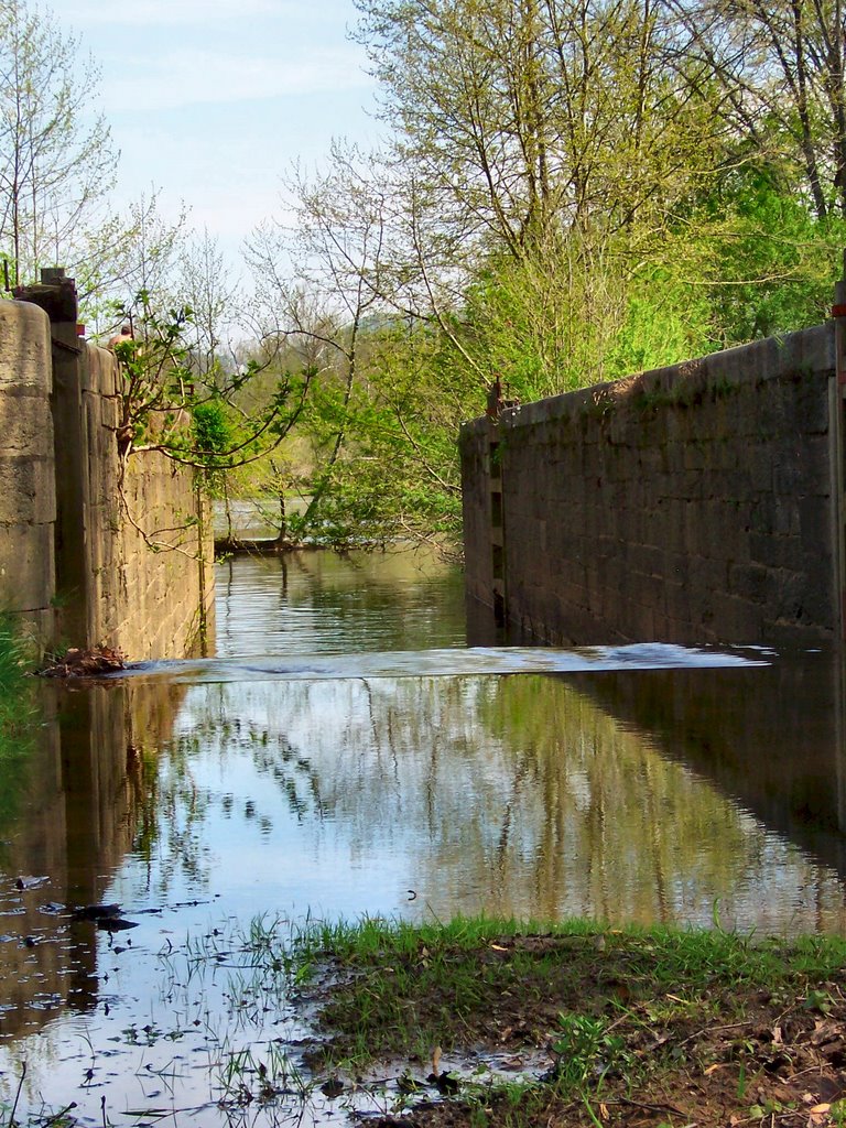
Image by D L Ennis, Looking through the Battery Creek Lock from upriver to the downriver entrance/exit

In the second half of the 20th century, portions of the old canal, locks, and turning basins became the source of renewed interest in Richmond and at other points along the line. As part of Richmond's revival and redevelopment of its waterfront, a portion of the canal was restored and now boat rides and a canal walk area are featured. Richmond's Canal Walk extends for a mile and a quarter parallel to the old Haxall and James River and Kanawha canals. Several historical exhibits about the canals themselves and the City of Richmond are dispersed throughout the length of the restored portion of the canal.

Much of the route of the connecting James River and Kanawha Turnpike portage through West Virginia is today the Midland Trail, a National Scenic Byway.

Near the James River visitor center, visitors can see one of the restored canal locks. The James River/Otter Creek recreation area is one of five developed areas along the Blue Ridge Parkway in Virginia, and is located near two highway crossings, state routes 501 and 130. Besides the visitor center, the area has a campground, restaurant/gift shop, picnic area, and handicap-accessible fishing dock.

An Interesting Side Note: In about 4,000 B. C. King Menes had the first, known, canal built in Upper Egypt.

First published on the Blue Ridge Gazette.


Technorati Tags: